"Man must rise above the Earth —to the top of the atmosphere and
beyond—for only thus will he fully understand the world in which he
lives."
Plato
11/14/2014
Gasometers - Vienna, Austria - 48.185°N 16.420°E
The
Gasometers in Vienna, Austria originally served as massive gas tanks
from 1896 to 1984. With the city's changeover from town gas to natural
gas starting 1969, the tanks were no longer used and were shut down.
However, the brick exterior walls were preserved and the structures were
repurposed with residential (~800 apartments) and commercial
(facilities include music hall, movie theater, and shopping mall) spaces
at the turn of the century.

49°20′3″N 5°5′36″E
November
11th is both Armistice Day (commemorating the armistice signed to end
the hostilities on the Western Front of World War One) as well as
Veterans Day in the United States (honoring those who have served in the
U.S. Armed Forces). Appropriately, today’s Overview shows Meuse-Argonne
American Cemetery near Romagne-sous-Montfaucon, France. The cemetery
contains 14,246 soldiers who died during WWI - the largest number of
American military dead in Europe. More than 9 million combatants and 7
million civilians died during the conflict that ravished Europe from
1914 to today's date in 1918.

Today marks the 25th anniversary
of the fall of the Berlin Wall. For the past two days, an installation
of 8,000 glowing balloons titled ‘LICHTGRENZE‘
(meaning "border of light"), has traced an approximately 15 km long
segment of the former course of the barrier that once separated the
German city in two.

A
drumlin is a mound, shaped like an inverted spoon or half-buried egg,
that is produced by receding glacial ice. When that land is then used
for agricultural purposes - like the drumlins seen here in
Campbellsport, Wisconsin - circular patterns rise to mimic the landscape
and make cultivation possible.

11/6/2014 - Hoover Dam - Clark County, Nevada / Mohave County, Arizona, USA
36°0′56″N 114°44′16″W
 11/5/2014 - Astana City Plan - Astana, Kazakhstan - 51°10′0″N 71°26′0″E
Astana is the capital and second largest city in Kazakhstan. South of the Ishim River that runs through the city’s center, there is significant construction underway. This process will remove the Soviet-era buildings and replace them with entirely new government administrative buildings, set for completion in 2030.
11/6/2014 - Hoover Dam - Clark County, Nevada / Mohave County, Arizona, USA
36°0′56″N 114°44′16″W
Hoover
Dam is a 726-foot high, 1,244-foot wide concrete arch-gravity dam
located on the Colorado River at the border of Arizona and Nevada.
Constructed between 1931 and 1936 during the Great Depression, a
workforce of approximately 20,000 poured a total of 4.36 million cubic
yards of concrete to complete the structure. Overall, there is enough
concrete in the dam to pave a two-lane highway from San Francisco to New
York.
Astana is the capital and second largest city in Kazakhstan. South of the Ishim River that runs through the city’s center, there is significant construction underway. This process will remove the Soviet-era buildings and replace them with entirely new government administrative buildings, set for completion in 2030.

On
December 4, a collection of Overviews will go on display at the
Deutsches Museum in Munich, Germany. Throughout the month, we will bring
back some of the selections for the “Welcome to the Anthropocene” exhibit, such as this Overview of vibrant tulip fields sprawling across the landscape in Lisse, Netherlands.

Approximately
seven million tires are buried in giant holes at a waste dump in
Sulabiya, Kuwait. It is believed that these tires originate both in
Kuwait as well as other countries who paid to have them sent here. For
example, since 2006 the EU has banned the disposal of tires in its
landfill sites, leaving 480,000 tons that need to be exported or
shredded each year.
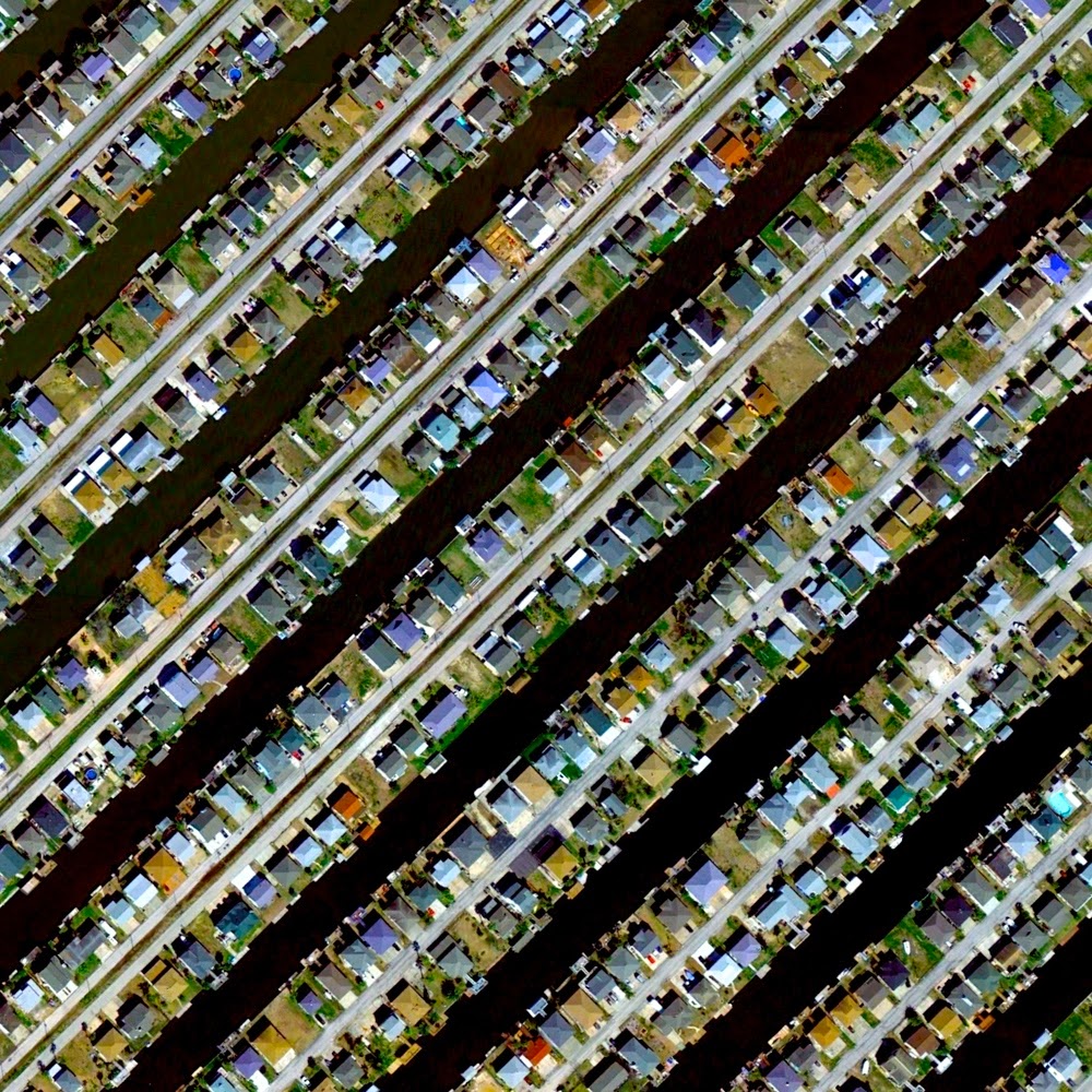
Residential housing separated by canals in Hitchcock, Texas, USA. Of the coastal town’s 92 square miles, more than a third is water.

10/29/2014- Bingham Canyon Mine - Salt Lake County, Utah, USA - 40.523°N 112.151°W
The
Bingham Canyon Mine is an open-pit mine where copper deposits are
extracted southwest of Salt Lake City, Utah, USA. The mine has been
operational since 1906 and has resulted in the creation of a pit over
0.6 miles deep, 2.5 miles wide, covering 1,900 acres. The Environmental
Protection Agency has estimated a 72 mile plume of contaminated
groundwater has been created over the course of the mine's history due
to numerous chemical and oil spills at the site.

Tondo is one of the most densely populated areas of the world with 72,000+ inhabitants per square kilometer. Located in the northwest portion of Manila, the capital of the Philippines, the district is primarily residential and contains many of the city’s slums.

Adolfo Suárez Madrid–Barajas Airport in Madrid, Spain processes more than 52 million passengers per year. The massive Terminal 4 (approximately 8 million square feet spanning two buildings) is designed to give passengers a stress-free start to their journey through careful use of illumination, glass panes instead of walls, and numerous domes in the roof which allow natural light to pass through.

In
a departure from our typical satellite Overview, today we want to share
a photograph with you that was captured recently by the National
Oceanic Atmospheric Administration (NOAA). The image shows 35,000
walruses gathered on the shore, five miles north of Point Lay, Alaska.
Environmental experts say the photograph is dramatic proof of changing
environmental conditions that result from sea ice loss. The accelerating
retreat of Alaskan sea ice north into the Arctic Ocean severely impacts
the walruses who rely on it for everything from giving birth to diving
to hunt for food.

Terraced fields swirl on the mountains outside of Lanzhou, China. The brilliant colors of the rock formations in the country's Gansu region result from red sandstone and mineral deposits that have settled over 24 million years.

Passenger
and freight trains wait in the rail yard at Hamm (Westfalen) Station in
Hamm, Germany. While the station now serves as one of the region's
major InterCityExpress passenger hubs, its marshalling yard operates at
only 10% of its original 10,000 wagon per day capacity following the
severe damage inflicted on it during World War II.

Vibrants
fields of rapeseed surround the town of Soest, Germany. Cultivated for
the oil produced by its bright-yellow flowers, Rapeseed has three
primary uses: (1) Vegetable oil for human consumption (2) Biodiesel,
used in both heating systems or blended with petroleum to power
automobiles and (3) High-protein animal feed that is created as a
byproduct of oil production.

Marina del Rey, California is the world's largest man-made small craft harbor. With docking capacity for 5,300 boats, the port is also considered "home" to approximately 6,500 vessels.

10/17/2014 - Memorial to the Murdered Jews of Europe - Berlin, Germany - 52°30′50″N 13°22′44″E
The
Memorial to the Murdered Jews of Europe in Berlin, Germany is dedicated
to the Jewish victims of the Holocaust. The 19,000 square meter site is
covered with 2,711 concrete slabs or "stelae", arranged in a grid
pattern on a sloping field. The stelae are 7 ft 10 in long, 3 ft 1 in
wide, and vary in height from 7.9 in to 15 ft 9.0 in. They are organized
in rows — 54 of them going north-south and 87 heading east-west — at
right angles but set slightly askew. The stelae are designed to produce
an uneasy, confusing atmosphere, and the whole sculpture aims to
represent a supposedly ordered system that has lost touch with human
reason.

Radiating streets surround the Plaza Del Ejecutivo in the Venustiano Carranza district of Mexico City, Mexico.

Zaatari Refugee Camp is a settlement located 10 kilometers east of Mafraq, Jordan. The camp first opened in July 2012 to host Syrians fleeing their ongoing civil war. While the number of refugees in Zaatari exceeded 156,000 in 2013, the current population estimate stands at 80,000.

10/10/2014 - E & J Gallo Winery - Modesto, California, United States - 37.634966515° -120.982344659°
The
E & J Gallo Winery is the largest family-owned winery in the United
States, headquartered in Modesto, California. During the fermentation
process, wine is kept under an airlock in massive stainless steel
vessels to prevent oxidation from occurring.

The
Port of Charleston in Charleston, South Carolina is the 8th busiest
port in the United States with $63 billion in imports and exports traded
across its docks. To accommodate larger ships, the U.S. Army Corps of
Engineers is planning to deepen Charleston Harbor from 45 feet (14 m) to
50 feet (15 m) by 2024.

Leisure World Seal Beach offers co-ops and condominiums for residents 55 years and older in Seal Beach, California, USA. With the first residents moving in on June 6, 1962, Seal Beach was the first major planned retirement community of its type in the United States.

10/7/2014 - Kobe Airport - Kobe, Japan - 34°37′58″N 135°13′26″E
Kobe Airport is constructed on an artificial island of the coast of Kobe, Japan. As seen in this time-lapse, the island and airport were built upon silt deposits over seven years at a cost of approximately 9 billion dollars.

10/6/2014 - Brighton Pier - Brighton, England, UK - 50°48′59″N 0°08′14″W
Brighton Pier, also known as Palace Pier, is constructed off the coast of the English city of Brighton. Extending 1,719 feet (524 meters) into the English Channel, the structure contains numerous restaurants, rides, and roller coasters.

The urban plan of the L’Eixample district in Valencia, Spain is characterized by long straight streets, a strict grid pattern crossed by wide avenues, and square blocks with chamfered corners.

9/26/2014 - Het Loo Palace - Apeldoorn, Netherlands - 52.234167°N 5.945833°E
Het Loo Palace is located in Apeldoorn, Netherlands. "The Great Garden,” situated behind the residence, follows the general Baroque landscape design formula: perfect symmetry, axial layout with radiating gravel walks, parterres with fountains, basins, and statues.

9/24/2014 - Intrepid Potash Facility - Wendover, Utah, USA - 40.690371478°, -113.918749132°
The
Intrepid Potash facility in Wendover, Utah has actively harvested
potash from naturally-occurring brines for the past 75 years. Covering
approximately 88,000 acres of land, brine is pumped from a ditch system
into an 8,000 acre solar pond to evaporate water and precipitate salts.
More than five billion gallons of brine are pumped into the solar pond
each year.

A turbine interchange connects the SR 9A and SR 202 in Jacksonville, Florida, USA. Also known as a whirlpool interchange, this structure consists of left-turning ramps sweeping around a center interchange, thereby creating a spiral pattern of right-hand traffic. This type of junction is rarely built, due to the vast amount land that is required to construct the sweeping roads.

The Mir Mine is an inactive, open-pit diamond mine located in Mirny, Eastern Siberia, Russia. The mine is 1,722 feet (525 m) deep and has a diameter of 3,900 feet (1,200 m), making it the second largest excavated hole in the world. Active for 44 years, the mine had an output of 10 million carats of diamond per year during peak production in the 1960’s.

Davis–Monthan
Air Force Base in Tucson, Arizona is home to the aircraft boneyard for
all excess American military and government aircraft. The 309th
Aerospace Maintenance and Regeneration Group takes care of more than
4,400 aircraft, making it the largest aircraft storage and preservation
facility in the world. We encourage you to explore the boneyard from
above with the geo-coordinates link above!

Industrial buildings line the coast of Tokai, Japan. The city’s economy is dominated by a massive steel mill operated by Nippon Steel, the second largest producer of steel in the world.

Balduina is a residential area in the Municipio XIX of Rome, Italy. At 456 feet (139 meters) above sea level, the neighborhood is highest part of the city.

9/12/2014 - University of Sharjah - University City, Sharjah, United Arab Emirates - 25°17′15″N 55°28′37″E
The
University of Sharjah is a private university located in University
City, Sharjah, United Arab Emirates. Of the school’s 100 million Dirham
(~27 million US dollars) construction cost, 90 million went towards
academic, scientific and administrative buildings and 10 million was
spent on landscaping the grounds and surrounding area.

The
Shin-Nagoya Thermal Power Station in Nagoya City, Japan is designed to
reduce annual CO2 emissions by approximately 1 million tons.
Additionally, in order to improve the scenic views of the plant, the
walls of the turbine building are painted blue and decorated with a
motif depicting the score of Mozart's "Symphony No. 40 in G Minor, K.
550."
 9/7/2014 - Pivot-irrigation fields - Plymouth, Washington, USA - 46.011747,-119.494514
Pivot irrigation fields stretch out from the Columbia River near Plymouth, Washington on the border with Oregon. Powered by electric motors, lines of sprinklers rotate 360 degrees to evenly irrigate crops.
Pivot irrigation fields stretch out from the Columbia River near Plymouth, Washington on the border with Oregon. Powered by electric motors, lines of sprinklers rotate 360 degrees to evenly irrigate crops.

Vineyards grow on the hillsides of Weinstadt, a town in the state of Baden-Württemberg, Germany. As the state’s fourth largest community of wine production with vineyards expanding a total of 489 hectacres, the town’s name appropriately translates as “Wine City”.

22.279534821°, 114.170375808°
Hong Kong Island (seen in the bottom half of this Overview) is one of the most densely populated areas in the entire world. With a total population of 1,289,500, there are 16,390 residents per square kilometer (41,057 / square mile).

The
Lancaster Water Reclamation Plant in Lancaster, California, USA
provides treatment for up to 18 million gallons of wastewater per day,
serving a population of approximately 160,000 people. In addition to
producing reclaimed water, the Lancaster WRP also processes all
wastewater solids generated at the plant. The solids are anaerobically
digested, centrifugally dewatered, and stored in concrete beds where
additional drying occurs before they are hauled away and beneficially
reused. Methane gas is produced during the digestion process and is used
to fuel the boiler used to heat the anaerobic digesters.

Overview of residential development in Lake Worth, Florida, USA. Much of the town is built on rapidly drained sand that also fosters the growth of tropical plants such as the coconut palm and avocado.

The
Cimitero Maggiore di Milano is the largest cemetery in Milan, Italy.
The cemetery has more than 80,000 square meters and is home to more than
500,000 graves. In the 19th century, as a consequence of the rapid
demographic growth of Milan, the city conducted a thorough
reorganization of its cemeteries and graves from at least four different
cemeteries were moved to the Maggiore.

The
Ivanpah Solar Electric Generating System is a solar thermal power
project in the California Mojave Desert, 40 miles (64 km) southwest of
Las Vegas, Nevada. It deploys 173,500 heliostats, each with two mirrors,
focusing solar energy on boilers located on three centralized solar
power towers (one of which is seen here). The receivers then generate
steam to drive specially adapted turbines. With a construction cost of
$2.2 billion and a planned gross capacity of 392 megawatts, Ivanpah is
the largest plant of its kind in the world.

8/20/2014 - Karl G. Jansky Very Large Array (VLA) - Outside of Socorro County, New Mexico,
34°04′43.497″N 107°37′05.819″W
The
Karl G. Jansky Very Large Array (VLA) is a radio astronomy observatory
located on the Plains of San Agustin, approximately 50 miles (80 km)
west of Socorro, New Mexico, USA. The observatory consists of 27
independent antennae, each of which has a dish diameter of 25 meters (82
feet) and weighs 209 metric tons. Astronomers using the VLA have made
key observations of black holes and protoplanetary disks around young
stars, discovered magnetic filaments and traced complex gas motions at
the Milky Way's center, probed the Universe's cosmological parameters,
and provided new knowledge about the physical mechanisms that produce
radio emission.

8/19/2014 - Port of Genoa - Genoa, Italy - 44.4028°N 8.91667°E
The Port of Genoa covers an area of about 700 hectares of land and 500 hectares of water, stretching more than 13 miles (22 kilometers) along the Italian coastline. With an annual capacity of 4 million ferry passengers, 1.5 million cars, and 250,000 trucks, Genoa ranks as the busiest port in Italy by cargo tonnage.
No comments:
Post a Comment